Mapping Praxis I: threads and butterflies

art, recent work

Since the Sigtuna working retreat in November, mapping procedures are on my mind… and all over the place; in books, notes and various materials. Reading and making. Seeking ways, following paths.

One accessible course would be to track the development of map projections, meant to change certain aspects of representation; to advance geodetics, to aestheticize or challenge general understanding – or combinations thereof, such as the “butterfly projection” invented by Bernard Cahill (1909)  and improved  by Gene Keyes (1975), the Dymaxion map by Buckminster Fuller (1943) and the reconsidered butterfly map by Steve Waterman (1996).

This slideshow requires JavaScript.

Three butterfly maps by Cahill and Keyes; Buckminster Fuller’s Dymaxion map; 2013 Waterman butterfly map;
images credit to Wikipedia commons and Gene Keyes’ website

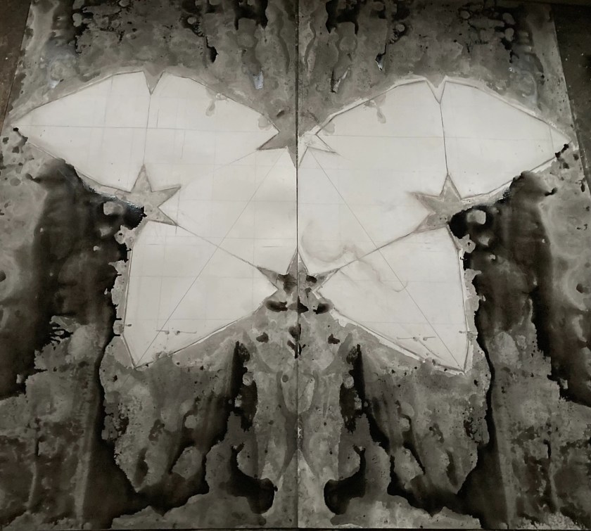
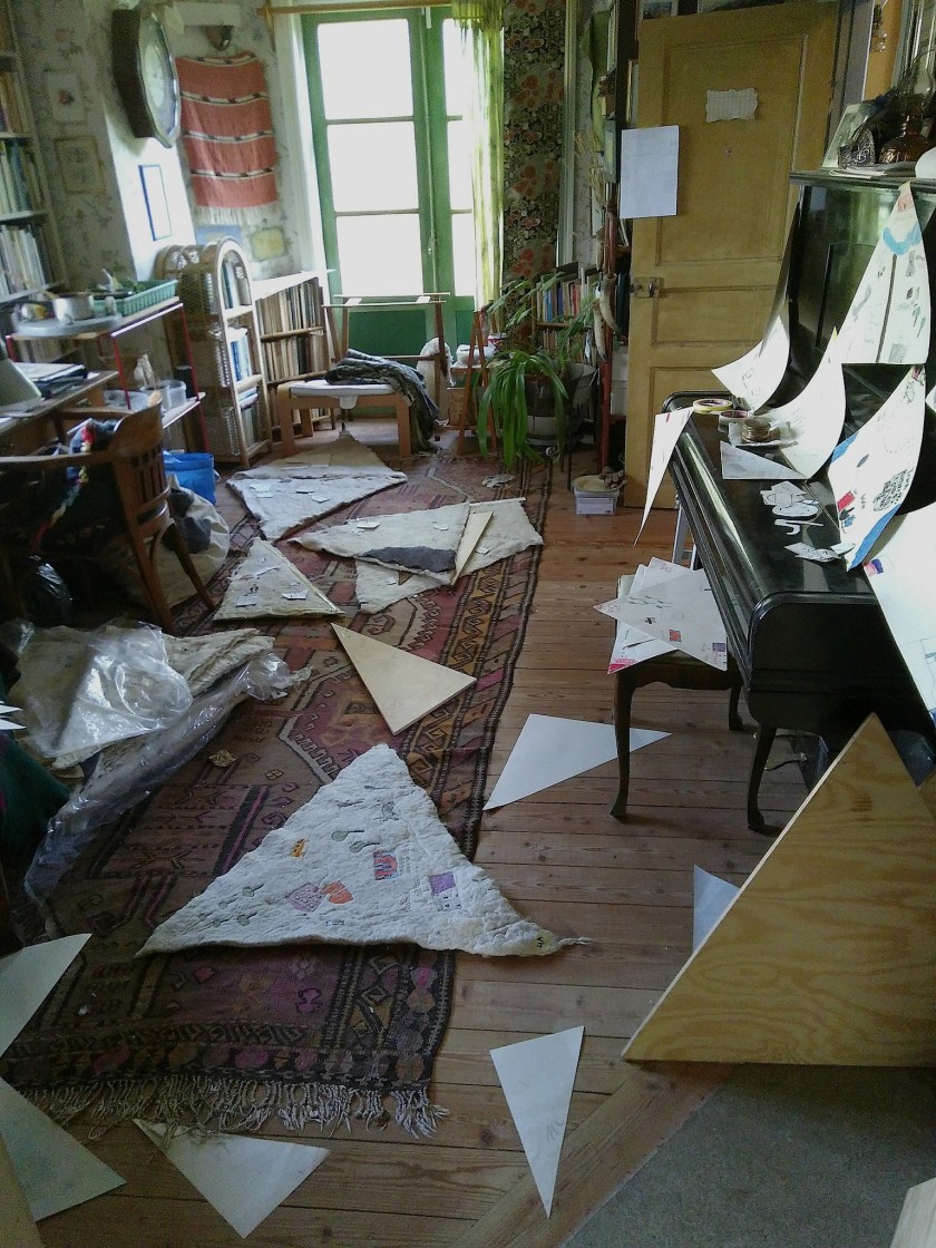
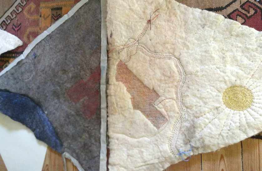
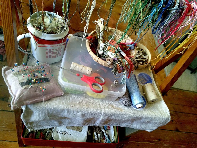
The butterfly map concept provides a starting point. As the Praxis group (and Nordic Summer University) gatherings generally take place in the Nordic-Baltic countries, I have chosen Waterman’s Europe-centered version (1996), reproducing it in varying sizes; A3, 1 x 2 metres and 2 x 2 metres. At the Sigtuna retreat, all participants were invited to mark their own places of special significance on the 1 x 2 metres map. Some persons pinned only one place, others many. Connecting the individual pins with embroidery yarn (remainders from the 2018 Star Roads project) casts a somewhat arbitrary net over the so far colourless cardboard…

Praxis “significant places’ map”; graphite drawing on cardboard, coloured map pins and mercerised cotton threads;
100 x  200 cms; (collaborative work in progress)

Connective threads and pinned places: silver grey: Purmo–Hosaina–Fiji; dark green: Puerto Maldonado (Amazonas)–Madrid–Tartu; greyish brown: København–Reykjavik–Vancouver–Lisboa–Stockholm–Post-Anthropocenic Speculative Diaspora; green: New York City; bright blue: Mariehamn–Lisboa–Åbo–Cottonwood–Kökar–Atupeva/Atupera?; brownish yellow: Herental / de Wimp; dark grey: Nakkila–Åbo–Haifa–North Namibia / Ovamboland; dark red: Alta; warm yellow: Seattle–Taos (New Mexico)–New York–Berlin; light yellow: Tejgadh–Frostviken–Melbourne–Stockholm; light violet: Örebro-Kåvi–Stockholm–Linnés Hammarby–Bern–Kailash–Helgum–Umeå–Lycksele–Visby–Dalhem (Småland).

Before the map, there were the tales of travellers. Before the concept of abstract space, there were a thousand and one places.

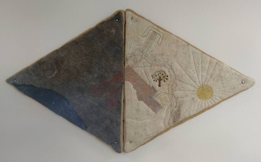
Helena Hildur W: two A3 size butterfly maps;
left: graphite pencil on paper; right: monoprint with graphite shading on paper

Notes from the Nordic Summer University II

art, curating, recent work, time-out

During the week-long NSU session, I got engaged in a couple of ‘ad hoc’ projects (in addition to my presentation within Circle 7, which was the ticket to my participation here). The first one happened in the context of a cultural evening.* Together with a number of courageous persons, I staged an updated performance of a multilingual poetry reading first realized in August 2014.**

evening-of-modern-ukrainian-poetry_small

2014 poster – for full story, see Training the Fundamentals of a Democratic Society

The original project sprung from a poem by Ukrainian author Tanya-Mariya Litvinyuk. In this re-staging, Ms. Litvinyuk is actually present through a sound recording sent from Kyiv the day before; her voice is heard from the laptop at the beginning. Then follows an English translation, read by Dr. Lucy Lyons, after which the English reading proceeds with ten words (all singled out from Ms. Litvinyuk’s poem). Back in 2014, those ten words sparked a collective writing process in a group of civil rights activists, and the poetic result of their joined efforts was translated from English into all languages spoken within the group. Here, I’m reading the Swedish version – followed by a fresh translation into Belarusian by NSU participant Alina Kalachova, created for this occasion. Crucial contributions (although not visible on screen) were also made by Maru Mushtrieva.

The multilingual reading evening engaged about 35 attendants, and took place in the school’s chapel.

My second ‘ad hoc’ engagement was in Disa Kamula’s workshop on Co-writing the future, where my contribution was the real-time mapping of an unfolding utopian narrative… From the resulting vision of a bright future, I finally erased all details but three:
…people of all ages…
…essential work… (cleaning up, that is)
…future generations in focus…

Mapping ‘Visionary Tampere Region’ workshop; resulting World Map,
and workshop leader Disa Kamula collecting workshop material afterwards.

What did I gather from this week? Art is knowledge, and artistic research is here to stay. Democratic structures are essential, although never perfect. Disco dancing is fun – thanks, Ami Skånberg Dahlstedt!
And the map is never complete.

* The NSU multilingual poetry evening was organized by Lara Hoffman, PhD student at Háskólanum á Akureyri, Iceland; she is also the editor of Ós – The Journal, a magazine which features works of fiction, poetry, creative non-fiction, and artworks in multiple languages.

** The 2014 Evening of Modern Ukrainian Poetry was organized by Yulia Oleksandriv and Julia Shevchenko, in collaboration with Stockholm International Library.

Public Commission VIII: Everything Coming Together (Finally)

art, recent work

School is closed for a week-long autumn break. I meet up with technician Per-Arne Sträng – who also happens to be an artist in his own right – to mount the map pieces. One and a half day of smooth collaboration…

This slideshow requires JavaScript.

…and – we nailed it! This is it.

181105 02b
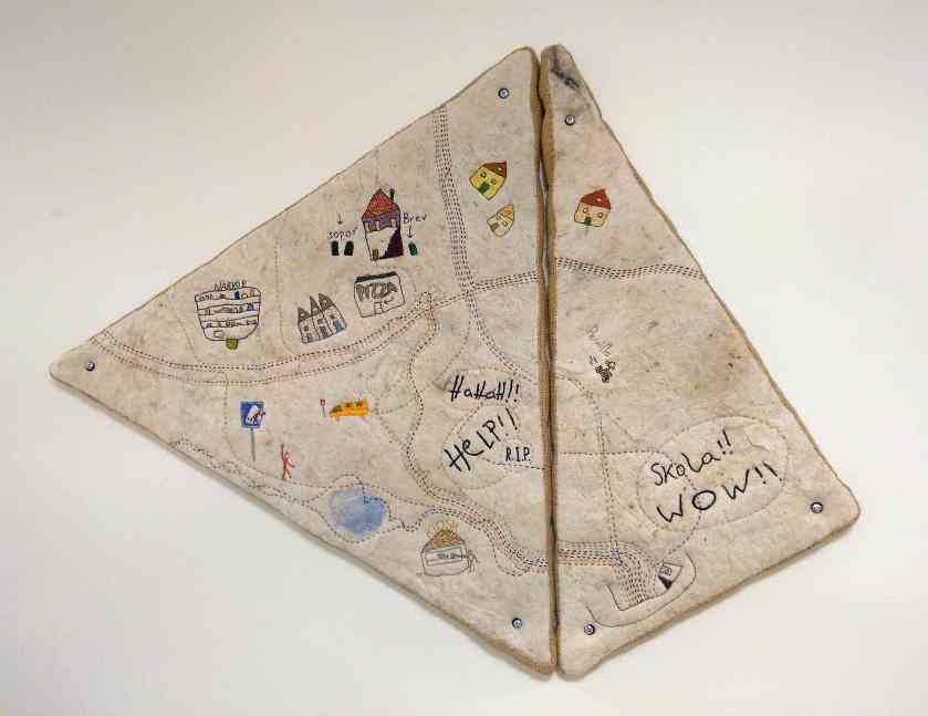
Cluster 1 (1A, 1B): the school building

*

xx

181030-13b.jpgCluster 2A – 2D; overview (above) and close-ups (below)

*

xx
xx

181109 01bClusters 3 (3A, 3B) and 4 (4A – 4F), overview

Cluster 3, close-ups

Cluster 4, close-ups

*

xx
xx

181101 01bCluster 5A – 5E, overview (above) and close-ups (below)

*

xx
xx
181109 02b

Cluster 6A, 6B, overview (above) and close-ups (below)

*

xx
xx
On Friday morning, Leif Josefsson – the school librarian – pops by and improvises an interview for the facebook site…

xx

*

xx
xx
So, this is really it; all the map pieces are mounted, the starry sky alcove is glowing, and the light projections are up and running.

180831 01b

Just one more thing for Monday;

181105 01b
let’s welcome everybody back to school with a surprise opening; snacks, grapes and applejuice… Good morning!

181105 09b

And now, it’s all yours. Enjoy!

181102 07.jpg

Public Commission VII: Embroidery Galore (August – October 2018)

art, recent work

With the starry sky alcove and the coloured spotlights set in place, I could return to the third part of the commission: the school road mapping.

Back in spring this year, schoolkids in two classes presented me with their hand-drawn maps – each one showing their own path from home to school. I began to fuse those forty-something individual images into one collective map. Some related to places that were easily recognizable, and some of their features were obviously identical; a supermarket, a traffic circle, those two water pools and the Thai restaurant. Others were very personal, and sometimes pertaining to different layers of reality; a secret tree-house, an encounter with a friend or a wild animal, or some wildly ambivalent feelings expressed in graffiti style… And there were suns, and moons, and stars.

Having arrived at an overview, I again divided the map in triangular parts and arranged the sketches in clusters designed for five different walls; now with the individual paths intertwined – sometimes interacting – and (almost) all ending up in the central piece with the school building.

Then, twenty-one pieces of felt were cut and prepared with starch. Similarly, twenty-one wooden boards were produced to tauten the felt pieces onto. And the embroidery race started…

180927 01b

It was pure delight to discover all the details of the kids’ maps; humorous – sometimes cheeky – emotional, colourful, observant and straightforward. In rendering their felt-tip pen drawings into yarn stitches, I did my very best to stay true to the original.

180925 02b

180927 05b

August and September came and went. Stitching, listening to the radio, stitching; pausing only to eat and sleep, and sometimes to go buying more mouliné thread… And slowly, the map took shape. By the end of October, I stowed the embroidery table away. The map was ready to mount.

181104 01b

Public Commission II; Mapping the School Road (March 2018)

art, recent work

What does “home” mean to you?
What does “school” mean to you?

Those were the questions I posed to the schoolkids in grade 2 and grade 5… Their answers? “Home” means family, granma and granpa, an annoying little sister, an easy feeling; a house, spaghetti, chips and snacks; love, memories, a native language; a shopping mall, or a beach – a wide range of emotions, persons, places, cognitions and things. And “school” could be anything between a prison and a safe place, associated with knowledge, effort, fun, weariness and sometimes injustice – and, above all, a place to be with friends.

IMG_0015

All the answers, written down on post it-notes, were carefully collected. Next time I visited, I presented them arranged in a pattern where “school” was the common centre, while the “home” notes formed a periphery – a proto-map, missing the in-between part; the school road. Which lead us to my next question: could you draw a map showing your way between home and school?

Denoyer-6-inch-globe-mapBernard J S Cahill: Butterfly Map (conceived in 1909)

Buckminster Fuller: Dymaxion Map (first published in 1943)

Inspired by Bernard Cahill’s “Butterfly Map” and Buckminster Fuller’s “Dymaxion Map”, I offered triangular pieces of drawing paper for the task. What I got in return was a stunning variety of expressions, mirroring individual temperaments and experiences – admirable visualisations and food for thought…

The next step will be the rendering of those school road maps into visual elements to form an aggregated whole, which can be mounted permanently on the walls. In the meantime, enjoy Jasper Johns’version of the Dymaxion map from 1967:

johns+film
Photo still from Jasper Johns: Take an Object,
a film by Hans Namuth and Judith Wechsler (1990)